| Main » Articles |
| Total entries in catalog: 89 Shown entries: 41-50 |
Pages: « 1 2 3 4 5 6 7 8 9 » |
|
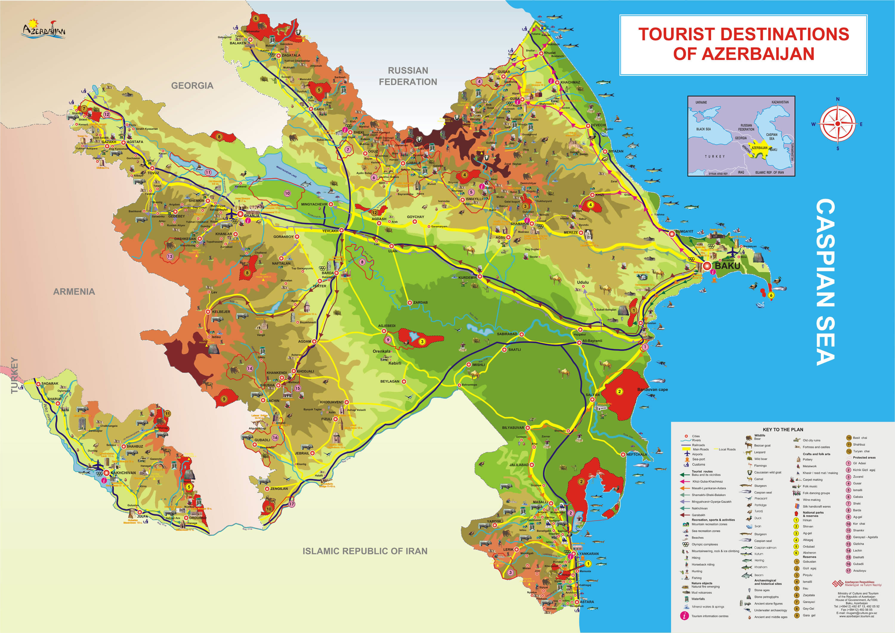
THE CLIMATE-FORMING FACTORS
Azerbaijan is situated on northern extremity of the subtropical zone, south-eastern Caucasus and north-western part of Iran plateau. Its climatic diversity is caused by the complicate geographical location and landscape, the proximity of the Caspian Sea, the effect of sun's radiation, air masses of different origin, etc. |
|
TECTONIC SETTING
The territory of the Republic of Azerbaijan forms a constituent geological part of the Alpine folded belt. Sedimentary deposits embracing the southwestern parts of the Major and Minor Caucasus, including the intermountain Kur-River trough, as well as the Mid- and South Caspian basins consist of diversity fold systems. The Earth's crust thickness in Azerbaijan varies in the range from 38 to 55 km. Its maximum thickness is observed in the Minor Caucasus area, while its minimum thickness is typical for the Talysh foothills. Geological setting of the area consists of sedimentary, volcanic-sedimentary, volcanic and terrestrial deposits embracing almost entire stratigraphic range beginning from pre-Cambrian period up to Holocene time.
The Great Caucasus meganticlinorium, the Kur River intermontane trough and the Minor Caucasus megasynclinorium constitute the principle structural systems in Azerbaijan. The Major Caucasus meganticlinorium has very intricate structural architecture embracing ancient geologic features along with those generated recently. All constituent structures of the Major Caucasus meganticlinorium abruptly plunge towards the Caspian basin and terminate entirely within the coastal area. The Yavandag-Sangachal gravity maximum is suggested to be a buried extension of the Vandam anticlinorium within the Shamahy-Gobustan synclinorium. Here, within Girdiman and Aghsu River interfluve Maykop deposits are overlain by thick (1500m) Cretaceous (Dibrar facies) deposits, referred to as the Baskal nappe with a 10km horizontal offset. Westward, within Mazim and Girdimanchay Rivers interfluve most of the southern part of the Vandam anticlinorium consists of sheet-like pebble deposits. |
 Mesozoic and Cenozoic eugeosynclinal, miogeosynclinal and molasse
deposits are most ubiquitous among the others. As for Paleozoic
sub-cratonic and the Alpine pre-Cambrian-Paleozoic metamorphic deposits
occupy much smaller areas.
Mesozoic and Cenozoic eugeosynclinal, miogeosynclinal and molasse
deposits are most ubiquitous among the others. As for Paleozoic
sub-cratonic and the Alpine pre-Cambrian-Paleozoic metamorphic deposits
occupy much smaller areas. |
OROGRAPHY AND VERTICAL MOUNTAIN ZONING
Quantitative area distribution according to their hypsometric levels is as follows: 18% of the area are located below the Ocean level, 24%-has hypsometric marks ranging from 0 to 200m, 15.5% is covered by areas which elevation ranges from 200 to 500m, another 15.5% are covered by areas which elevation marks ranges from 500 to 1000m, 19.5% are covered by areas which elevation ranges from 1000 to 2000m high, 6.5% are covered by areas which elevation ranges from2000 to 3000m, and only 1% is the areas which elevation marks are over 3000m high. Average elevation is 384m high. Principle orographic units of Azerbaijan Republic consists of the Great Caucasus mountain system, Samur-Davachi lowland (in conjunction with Gusar inclined plain), Kur River lowland, Minor Caucasus and Talish mountain systems. Only southeast part of the Great Caucasus mountain region is located within Azerbaijan Republic. The basic orographic elements of this part of Great Caucasus system are Major Caucasus system (or watershed ridge) and the Lateral ridge. Major Caucasus ridge constitutes large portion of the Great Caucasus system and extends southeast off Tinov-Rosso elevation (3385m) is located at Azerbaijan State border with Georgia and Daghistan AR. Only southern flank of the ridge between Tinov-Rosso and Bazar-Dyuzu (the northern flank of the ridge belongs to Daghistan AR), where both flanks of that part belong to Azerbaijan. The Major Caucasus watershed ridge is not crossed with any river valleys (and therefore it is also called Watershed ridge). Most part of the ridge elevation is over 3000m high, and only in its central part it exceeds 4000m height (Bazar-Dyuzu - 4466m, Tufandagh-4191m, Bazaryurd- 4126m). Beginning from Babadagh peak (3629m) the same ridge elevation gradually goes down and becomes wider. Starting from Dubrar elevation (2205m) Major Caucasus ridge plunges northeastward towards Caspian Sea like expanded fan having been cut by river valleys into separate ridges like Gadi-Kurkachidagh, Aladagh, Kemchi and others. |
 The Republic of Azerbaijan is typified by relief of different kinds and
complexity. Over half of the country's area consists of the mountain
ridges, crests, yailas and plateaus rises up to hypsometric levels of
400-500m, (or up to 800-1000m within the Middle and Lower Araz
lowlands), in some places (Talis, Jeyranchol-Ajinohur and Langabiz-Alat
foreranges) up to 100-120m, as well as 0-50m up (Gobustan, Absheron) the
rest part of which are plains and lowlands. Hypsometric marks within
the Great Caucasus region vary in the range from about -28m at the
Caspian Sea shoreline up to 4466m, (Bazardyuzi peak).
The Republic of Azerbaijan is typified by relief of different kinds and
complexity. Over half of the country's area consists of the mountain
ridges, crests, yailas and plateaus rises up to hypsometric levels of
400-500m, (or up to 800-1000m within the Middle and Lower Araz
lowlands), in some places (Talis, Jeyranchol-Ajinohur and Langabiz-Alat
foreranges) up to 100-120m, as well as 0-50m up (Gobustan, Absheron) the
rest part of which are plains and lowlands. Hypsometric marks within
the Great Caucasus region vary in the range from about -28m at the
Caspian Sea shoreline up to 4466m, (Bazardyuzi peak).
|
OROGRAPHY AND VERTICAL MOUNTAIN ZONING
Quantitative area distribution according to their hypsometric levels is as follows: 18% of the area are located below the Ocean level, 24%-has hypsometric marks ranging from 0 to 200m, 15.5% is covered by areas which elevation ranges from 200 to 500m, another 15.5% are covered by areas which elevation marks ranges from 500 to 1000m, 19.5% are covered by areas which elevation ranges from 1000 to 2000m high, 6.5% are covered by areas which elevation ranges from2000 to 3000m, and only 1% is the areas which elevation marks are over 3000m high. Average elevation is 384m high. Principle orographic units of Azerbaijan Republic consists of the Great Caucasus mountain system, Samur-Davachi lowland (in conjunction with Gusar inclined plain), Kur River lowland, Minor Caucasus and Talish mountain systems. Only southeast part of the Great Caucasus mountain region is located within Azerbaijan Republic. The basic orographic elements of this part of Great Caucasus system are Major Caucasus system (or watershed ridge) and the Lateral ridge. Major Caucasus ridge constitutes large portion of the Great Caucasus system and extends southeast off Tinov-Rosso elevation (3385m) is located at Azerbaijan State border with Georgia and Daghistan AR. Only southern flank of the ridge between Tinov-Rosso and Bazar-Dyuzu (the northern flank of the ridge belongs to Daghistan AR), where both flanks of that part belong to Azerbaijan. The Major Caucasus watershed ridge is not crossed with any river valleys (and therefore it is also called Watershed ridge). Most part of the ridge elevation is over 3000m high, and only in its central part it exceeds 4000m height (Bazar-Dyuzu - 4466m, Tufandagh-4191m, Bazaryurd- 4126m). Beginning from Babadagh peak (3629m) the same ridge elevation gradually goes down and becomes wider. Starting from Dubrar elevation (2205m) Major Caucasus ridge plunges northeastward towards Caspian Sea like expanded fan having been cut by river valleys into separate ridges like Gadi-Kurkachidagh, Aladagh, Kemchi and others. |
|
GENERAL INFORMATION ON NATURE OF AZERBAIJAN
Favorable natural and geographical conditions of Azerbaijan caused the settling of people on its territory.
Later Arabian geography scientists and travelers Ibn Khordadbeh (820/826-912/913), Abu-Ishaq Isterkhi (appr. 820-934), Azerbaijani scientist Mohamed Nakhchivani (late 13th-mid 14th centuries), Iranian scientists Reshidaddin Fazlullah (1247-1317) wrote about the economics of Azerbaijan, its administrative division, mountains and rivers, the distances between them, trade roads, etc. Albanian (Caucasus) historian Musa Kalantarli (7-8th century) in his work "The History of Albania" described Albania as a world-famed country with a rich nature and dense population, fertile soils, beautiful gardens and green plains. The world map (1459) of Venetian F.Maurov, the maps of Alsharif (1601), german scientist and traveler A. Olear), as well as the map "East Transcaucasia and the Caspian Sea", drawn in 1720 and issues in 1723 by order of Peter the First included the inhabited regions, lakes and rivers of Azerbaijan. Azerbaijani geographical scientist Abdurrashid Bakuvi expressed his views on the climate of Azerbaijan, the nature of Baku and oil production in this town, Hadji Zeynalabdin Shirvani and Abbasqulu Aga Bakikhanov shared their opinions on the geographical features of our country. V.Abikh, I.Figurovsky, A.Zakharov and others made a great contribution to exploration of the territory of Azerbaijan as well. Complex exploration of Azerbaijan started in period of the Soviet Union, when different scaled maps were issued and geographical atlases drawn. The Academy of Science of Azerbaijan played an important role in comprehensive study of the territory of our country. |
 Ancient writers Herodot (5th century B.C.), Polibey (200 B.C-120 B.C),
Strabon (64/63- B.C-23/24 A.M), Claudi Ptolemey (approximately 90-160)
and provided coverage of geographical borders of Azerbaijan, rivers,
inhabited regions, tribes, residing in the country, the Caspian Sea in a
number of their creative works.
Ancient writers Herodot (5th century B.C.), Polibey (200 B.C-120 B.C),
Strabon (64/63- B.C-23/24 A.M), Claudi Ptolemey (approximately 90-160)
and provided coverage of geographical borders of Azerbaijan, rivers,
inhabited regions, tribes, residing in the country, the Caspian Sea in a
number of their creative works.
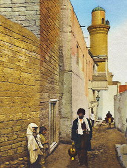 Water seller. End of 19th century by Kamil Farhadoglu All of Baku used to be located within the area of the presentday Icheri Sheher, i.e. actually Baku was Icheri Sheher. In the first half of the 19th century, the city began to grow and expand beyond the fortress walls. As a result, the fortress came to be called "Icheri Sheher” (Inner City) and what was outside was the "Outer City”. When Icheri Sheher was being built in the Middle Ages, it consisted of twisting streets which defi ned small neighbourhood areas – there were nine in all. Each area centred on its mosque: the Juma mosque, Shah mosque, Mahammadyar mosque, Haji Qayib mosque, Hamamchilar mosque, Siniqqala mosque, Qasim bay mosque etc. Each had its own mullah. Each to his ownSome of the areas were named after people who had arrived in Baku and settled in Icheri Sheher. The Gilaklar block was occupied by merchants who had arrived from Gilan. Gunsmiths from Dagestan lived in the Lezgi block. Most of the population of Icheri Sheher were craftsmen, merchants or sailors. Some areas were named after the professions of the craftsmen who lived there. The Hamamchilar (bathhouse workers), Bazzazlar (leather workers), Hakkakchilar (engravers) etc. The people of Icheri Sheher – Azerbaijanis – also fell into various clans. Some of them had very interesting names. 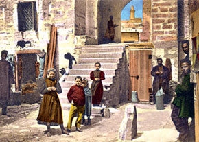 Near the Small Caravanserai. Late 19th century Near the Small Caravanserai. Late 19th century Each had a nickname: Plasterer, Mule, Thank-you, No-Cheese. Or Agamali, always ready to give a helping hand, was nicknamed Shortie because he was.... not very tall. |
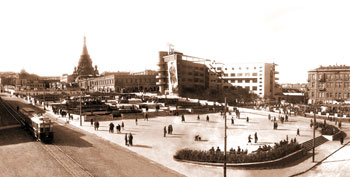 Part of Parapet Square, 1930s (now Nizami square) Part of Parapet Square, 1930s (now Nizami square) by Kamil Farhadoglu Baku’s incorporation into the Russian Empire in 1806 marked the start of a new phase in the city’s development, both in terms of layout and architecture. The city changed even more dramatically after it was given the status of a governorate in 1859. |
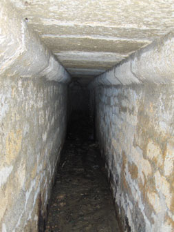 by Dr. Kamil Ibrahimov Restoration work in Vahid Park, the former Governor´s Park just outside the walls of Baku´s Old City on the Azneft side, has unearthed an underground passage. Archaeologist Dr Kamil Ibrahimov, senior researcher at the Old City State Historical and Architectural Reserve, looks at the history of the passage and what it tells us about the Old City´s water supply system. First of all, it is important to identify the newly discovered underground passage in historical and archive maps and other sources. |
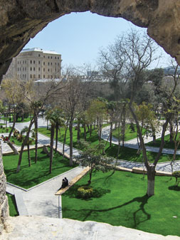 by Kamil Ibrahimov Restoration work is now complete at the Philharmonia Park, just outside the walls of Baku´s Old City. The park, formerly known as the Governor´s Garden or Vahid Park, slopes down towards the Caspian from the Philharmonia Concert Hall. Dr Kamil Ibrahimov, senior researcher at the Old City State Historical and Architectural Reserve, takes a look at how this lush park came to be created in arid Baku. |