| Main » Articles » CAPITAL |
Building Work Reveals More Of Baku's History
Facts and figuresThe underground passage starts from a cell. The descent to the cell may date back roughly to the 1870s-80s. It is followed by a tunnel which is approximately human height and over half a metre wide. A preliminary study of some 200 to 250 metres of the underground passage shows that initially it heads towards the road and then towards the sea, while in the 19th century sewage outlets were attached to it. At the same time, there is good reason to assume that the original function of the underground passage during the early medieval period was to carry water to supply the Old City (Ichari Shahar). However, later restoration work adapted the old water channel for other practical uses. The hypothesis can be verified 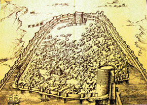 Baku in the 12th century, reconstruction by architect Sheblik, 1941 Baku in the 12th century, reconstruction by architect Sheblik, 1941 Brief overview of historical sourcesThe Old City is known to have been supplied with water by three water-pipelines: the Mammad-Qulukhan, Huseyn-Qulukhan and Shah lines. Information about this underground water supply system can be found in F.I. Saymonov´s 1763 Description of the Caspian Sea (Opisaniye Kaspiyskogo morya) and several works by researchers during the Soviet period which are listed in the Bibliography below. Archaeologist F. Ibrahimov wrote about archaeological research into Baku´s underground water supply system in the late 1970s and early 1980s. Russian military engineers compiled maps and plans of Baku which are stored in the central military engineering museum in Moscow. A Baku plan, made in July 1796 by Engineer Col Kh. Truzson, shows two water pipelines with a brief note ´water drain pipes laid from mountain springs to wells in the Fortress [Old City]´. A map drawn by a major in October 1806 entitled Plan of the 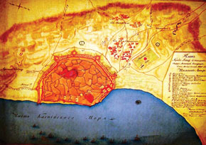 Map of old Baku, drawn by Russian military specialists, 1806 Map of old Baku, drawn by Russian military specialists, 1806 A plan of the city of Baku dated August 1807 and entitled General Plan of the City of Baku and its Environs with an Appendix Showing the Reinforcements Required for Better Defence also shows three underground water supply lines marked in the plan with the letter X. A more detailed plan of Baku, dated 9 March 1808, is entitled General Plan of the City of Baku and its Environs Showing the Pipelines Supplying Fresh Water to the City. The plan is interesting as the letters A, B and C mark the underground water supply lines Magmet-ulikhanskaya (Mammad-Qulukhan), Shakhskaya (Shah) and Guseyn-Kulikhanskaya (Huseyn-Qulukhan) respectively. Cross sections with explanations show the construction of the water pipelines. With the help of the maps, therefore, it is possible to confirm the presence of an underground water supply system consisting of three water pipelines, their sources, routes and points of entry into the Old City. However, the most interesting resource in terms of identifying the underground passage is a set of sketches dated 30 October 1809 and entitled 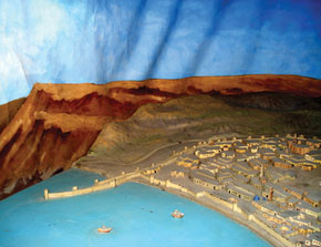 Model of Baku in the 12th century Model of Baku in the 12th century Conclusions based on historical sources and mapsa) It follows from the archive documents that by the end of the 18th century the city of Baku was supplied with fresh water by three underground water supply systems that brought water to the city from springs which were located a long way from the Old City walls. The branches of the trunk supply line were called Shah, Mammad-Qulukhan and Huseyn-Qulukhan. b) The water pipelines were connected by means of a fourth underground water supply line with four 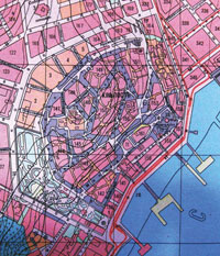 Street map of Old City, 1889-1900 Street map of Old City, 1889-1900 c) The sources of the underground water supply systems, their routes, points of entry into the Old City, the location of outside reservoirs and their connection to the unified water supply system are known. It follows from archive sources that the Shah water pipeline, with water that the residents appreciated, was built in the 14th-15th centuries in connection with the completion of the Shirvanshah Palace complex. This underground water supply line entered the Old City near the building that houses the present-day city executive authorities and supplied water to the palace complex and the nearby area. Everybody knows that now, too, the famous ovdan well, where there is always water, has been a storage facility for this water pipeline for many centuries. The Shah water pipeline originated from three springs in the upper, northern part of the city. The Huseyn-Qulukhan underground water supply line is a complex system, fed from two springs, which ran down to the area of the former Husi Hajiyev Street, headed to the Shamakhi Gate (the Qosha Qala Gate), and entered the Old City there, supplying water to the eastern and south-eastern parts of the city that were known for their commercial activity - caravanserais, bathhouses and marketplaces. The pipeline was actually found in 1964 during excavations on the Arcade. The pipeline dates back to the 14th-17th centuries. Finally, the Mammad-Qulukhan underground water supply line supplied water to the western and southern parts of the city. It entered the Old City near the present-day Philharmonic Hall and originated from two springs on the hill 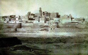 Baku, 1876 Baku, 1876 Archaeological evidenceA water pipeline that ran from north-west to south-east towards the Old City was found during building work at the intersection of Lermontov Street and former Krasnaya Street (now Sheikh Shamil Street) back in 1953. Water was transported via this channel from underground springs located uphill in Chambarakand. Another branch of the water pipeline, which was found simultaneously in the upper part of Sheikh Shamil Street, joined the first pipeline near the city walls. It was studied by Academician A. Alizada. It emerged later that the two branches of the water pipeline, the Mammad-Qulukhan and Shah, fed from springs in the north-western and northern parts of the uphill plateau respectively, converged near the Old City walls. It was believed that these were branches of one and the same Shah water pipeline, but specialists later established that the underground spring found at the intersection of Lermontov and Krasnaya 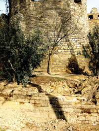 Excavations around the walls of the Old City Excavations around the walls of the Old City An underground water supply line which fed water to bathhouses located in the south-west of the Kasum-Bek Fortress was found during work in the Old City and outside its walls in the early 20th century. Part of the water pipeline was outside the city walls and was simultaneously used as an underground passage leading out of the city. According to archive documents, the newly discovered water pipeline was part of the Mammad-Qulukhan underground water pipeline that supplied the southern and south-western part of the old town. As was noted, this line was fed by springs in Chambarakand (Martyrs´ Avenue), crossed Istiqlaliyyat Street near the Philharmonic Hall and ran towards the Salyan Gate. Several sections in the upper part of the water pipeline were destroyed during construction work, which allowed its direction to be determined. However, construction work in the south of the city near the Haji Gayib bathhouse and a two-storey caravanserai revealed a water pipeline at a depth of six metres that was a branch of the Mammad-Qulukhan water pipeline. And last, but not least, a reservoir and the remains of a water pipeline connected, probably, to an underground water supply line running from Chambarakand were found during archaeological research in the eastern and south-eastern parts of the Old City in 1981. Approximately in the 1950s, another underground water supply system was found 400-500 metres east of the city wall near Husi Hajiyev and Kasum Ismayilov streets, and Tolstoy and the former Pionerskaya streets that cross them. It was found when a pit was 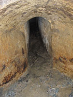 Small room at the entrance of the underground passage discovered near the Old City Small room at the entrance of the underground passage discovered near the Old City The main gallery continued in a direct line towards the upper part of the city and its extension probably also served as an intake for other parts of the underground water supply system. In other words, the main gallery collected water from all water-bearing strata that lay above it in the upper part of the town and it was presumably connected by underground galleries to wells in the upper part of the city. A branch of the water pipeline that served the commercial area was found in the eastern part of the Old City during excavations in 1981. What is more, a large water supply facility was found there - a depot with a water distributor connected to the Huseyn-Qulukhan water pipeline. An underground passage, found by archaeologist V.M. Sysoyev near the Maiden Tower in 1924, served not only to evacuate people during enemy sieges but also as a water pipeline to supply the eastern and south-eastern part of the city and was connected to the Huseyn-Qulukhan underground water supply system. Archaeologists found drains from the eastern branch of the water pipeline, which ran towards the Puppet Theatre from under the city walls. And, finally, the Shah water pipeline - water canals from 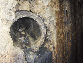 Underground water pipes Underground water pipes Two important things can be noted in conclusion of this section. First of all, in 1986 archaeologists found special underground reservoirs (cut into the rocks) to collect and cool moisture alongside ordinary reservoirs for collecting water in the upper part of the city, where underground water supply lines originate. Archaeological studies in the Old City made it possible to conclude that the underground water supply system created over the centuries had operated back in the 11th-13th centuries and was developed and improved in the 14th-15th centuries. What was the underground water supply system like?The Baku underground water supply system consisted of three 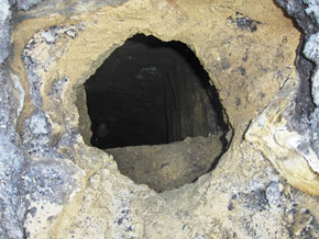 Underground water pipes Underground water pipes canals cut into rock or made out of rock observation wells domed cisterns-cum-reservoirs (water storage facilities) This system also included ovdans (fountains/wells) at the approaches to the Old City and inside it, which served as places where the population could collect water. An underground water supply system, a pipe-cum-tunnel, absorbed ground waters within a certain stratum of rocks. The underground water supply tunnel itself normally had a diameter of 0.5 x 0.75 or 1.0 x 1.5 metres with a flat or domed covering. An underground water supply line consisted of earthenware pipes, 45-55 cm in length, inserted into one another with a special solution (kej - putty) applied to their joints. Every 25-30 metres shafts-cum-wells were used for the removal of earth and ventilation. The wells were tiled with stone and brick and were used for water collection. In the Baku area, the system of underground water supply pipes had one more peculiar feature: the condensation of steam flowing in the high parts of the plateau played a great role in feeding the water-bearing strata. Hence the emergence of springs that fed the underground water supply system in medieval Baku. How did the Baku underground water supply system operate?Since water came into and moved in the underground water supply pipes on its own, the pressure of the flow increased considerably on the steeper slopes. For this reason, ´pocket wells´ and reservoirs 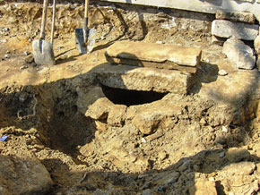 These water storage facilities - ovdans - were connected to the water pipeline system inside the city. In particular, the internal ovdan at the palace complex, the largest one on the Absheron Peninsula, not only supplied drinking water to the palace complex and the western and southern parts of the city but also played the role of a central distributing station in the water pipeline system inside the city. The ovdan was capable of supplying water for a long period both when the outer water pipeline broke down and during sieges. What was the function of the fourth water pipeline?The fourth water pipeline encircled the Old City. It started practically near the present-day Qosha Qala Gates, ran along Istiqlaliyyat Street and slightly up to the north and north-west, and passed through the former Governor´s Park in the west and then via Azneft Square reached the sea. It also had one branch in the form of a discharge outlet into the sea in Aziz Aliyev Street. Along its route there were buffer reservoirs-cum-water 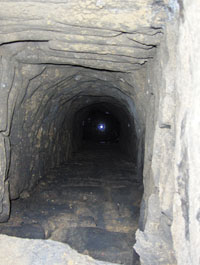 Underground water supply system Underground water supply system The main function of the collector grid was to receive water running into the water pipeline from springs and to ensure the renewal of water in the buffer water storage facilities. The outer grid of the Baku water pipeline was able to take the unused surplus water out to sea. After the Mammad-Qulukhan line approached the outer grid near the Philharmonic Hall, it went south towards the water storage facility near the pool below the Governor´s Park and then slightly eastwards, going through another water storage facility near the Salyan Gate and then had access to the sea. This section of the outer water pipeline could be viewed as a continuation of the Mammad-Qulukhan branch of the underground water supply pipe. The underground water supply system was built on the following principles: First, water from fresh water springs ran on its own down to the Old City, owing to the natural relief of the area, and filled the water cells (water storage facilities) near the outer settlement; Second, the water storage facilities were natural regulators of possible seasonal fluctuations in water consumption and also ´moderated´ the intensity of the water flow, and were constantly renewed by the inflow of fresh water; Third, used water flowed to the sea through channels due to the relief of the area, because of which the underground water supply system, with reservoirs-cum-water storage facilities, was linked as much as the relief 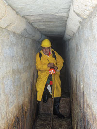 Underground passage and water wells Underground passage and water wells ConclusionThe underground passage with a cell found during construction work corresponds to the channel of the section of the collector grid and water storage facility in the former Governor´s Park which is marked in the relevant archive maps and plans of the city of Baku. Initial studies by archaeologists who visited the underground tunnel testify that its direction towards the sea is similar to the direction indicated in the sources. No cement was used in the masonry of the underground passage and technologically it is close to the masonry of the Old City walls. Remains of stones from destroyed city walls were certainly used during the construction of this underground tunnel. The initial height of the underground passage of about 1.65 metres goes down after the first few dozen metres to 1.1-1.2 metres. As the initial studies showed, before it reaches the Salyan Gate, the underground passage has an offshoot with a narrow domed hole towards the Old City. According to old maps, a reservoir should have been in this 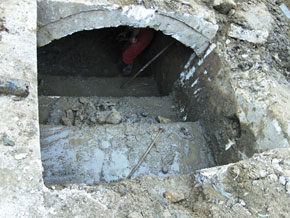 Entrance of the underground passage Research into an area 150-200 metres from this route shows that after the Salyan Gate there is a sharp narrowing and incline in the underground canal. This can be explained logically because from this section there was no practical point in a water inlet into the Old City and unused water was discharged into the sea. Additional excavation work will probably make it possible to establish the presence of the nearby reservoir indicated in archive maps. At the same time, an initial analysis showed that despite the similarity between the masonry of the wall of the underground passage with that of the Old City walls, repair work was done here in the 1870s or 80s, which widened the old channel and turned it into a system to discharge waste water. Further evidence of this is provided by the drains, made from relatively modern materials, that go into the channel, including, judging from materials used, drains made in the mid-20th century too. At the same time, the old channel is preserved and its bottom is covered with a considerable layer (up to 20 cm) of earth, clay and various mantles and, very possibly, is paved with stone tiles ´in the style of the 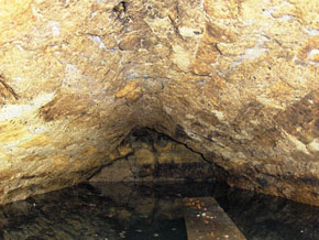 Underground water reservoir discovered outside the walls of the Old City So, the theoretical conclusion is that the newly discovered underground passage (tunnel) is an ancient medieval channel of the collector part of the Baku underground water supply pipeline that encircled the Old City along the outer settlement of the Mammad-Qulukhan branch of the underground water supply system which was slightly modified later and rebuilt as a sewerage system. The theory is also confirmed by the fact that the Mammad-Qulukhan branch of the water pipeline, the nearest to this sector of the collector grid, was, according to Russian military engineers, blocked up by the early 19th century and was not used by residents for water collection. The Shah line dates back to the 14th-15th centuries while the Mammad-Qulukhan and Huseyn-Qulukhan pipes (named after the Baku khans) were commissioned in the 17th century and after repair and reconstruction work by the relevant Baku khans were named after them. It can be assumed that these branches of the underground water supply pipes were built into the collector grid which encircled the Old City and was built during the creation of the Shah line. Therefore, this dates the underground passage to no later than the 15th century. Literature F.A. İbrahimov, Bakıda 1982-ci aparılan arxeoloji qazıntının hesabatı (Report Of Archaeological Research Conducted in Baku in 1982), Archives of the Azerbaijan Academy of Sciences Archaeology and Ethnographic İnstitute, collection 1, 0-16, volume 991612. F.A. İbrahimov and O. Sh. İsmizada, Bakının qədim su kəməri (Baku`s Ancient Water Pipeline), Science and Life journal (Elm və həyat), №6, Baku, 1981. A.A. Salamova, B.A. Sadikhov, Moltanı karvansarayında bərpa işləri (Restoration Work at the Moltan Caravanserai), Azerbaijan Monuments academic journal (Azərbaycan abidələri), № 1, Baku, 1984 . A.A. Ali-zada, Социально-экономическая и политическая история Азербайджана XIII-XIV vv (Socioeconomic and Political History of Azerbaijan in the 13th to 14th Centuries), Baku, 1956. F.A. İbrahimov, O. Sh. İsmizada, V.P. Fomenkov, R.J. Akhmadov, S.B. Huseynova, Arkheologicheskiye raskopki 1979 goda na territorii İcheri Sheher (Archaeological Excavations in 1979 on the Territory of the İchari Shahar), Archaeological and Ethnographic Research in Azerbaijan, Baku Science Publishers, 1984 A.B. Salamzada, O Bakinskom vodoprovode feodalnogo perioda (On the Baku Water Pipeline of the Feudal Period), Reports of the Academy of Sciences of the Azerbaijan SSR, volume XII, № 3, Baku, 1956. V.M. Sysoyev, Kratkiy ocherk istorii Azerbaydzhana (Brief Overview of the History of Azerbaijan), Baku, 1925, p.63 Kamil Farhadoghlu, Bakı İçərişəhər (Baku`s İnner City), Baku, volume II, 2006 F.I. Saymonov, Описание Каспийского моря 1763 (Description of the Caspian Sea 1763), 1440, Azerbaijan Academy of Sciences Library. Средневековый водопровод в крепости Баку (The Medieval Water Pipeline in Baku`s Old City), Vyshka Newspaper, 11 January 1959. S. Silvestrov, XV век под нашими улицами (The 15th Century Beneath Our Streets), Молодежь Азербайджана newspaper, 22 December 1961. Kamil Farhadoghlu, Baku Reveals its Secrets, Visions of Azerbaijan magaqzine, Baku, 2009 Kamil Farhadoghlu, İçərişəhər – arxeoloji abidələr (Archaeological Monuments of the İnner City), Baku 2008 Kamil Farhadoghlu, Bakının orta əsr su təchizatı (Baku`s Medieval Water Supply), Baku 2007. Kamil Farhadoghlu, Fortifications of Baku`s Old City, 2008. Source: http://www.az-tourizme.tk/ | |
| Category: CAPITAL | Added by: shamsi_84 (08.05.2011) | |
| Views: 1159 |